







FIP-2200 (SatLink) Satellite Ground Station & Remote Sensing Center
Original price was: ₱7,591,500.00.₱0.00Current price is: ₱0.00.
Earth-observation services supporting agriculture and disaster response.
| Land Area: | 0.94 hectares |
390 in stock
Future Arenas Innovation Park
FIP-2200 (SatLink) Satellite Ground Station & Remote Sensing Center
Bridging earth and orbit through innovation.
Vision and Identity
SatLink envisions Earth connected seamlessly to orbit. By advancing satellite communications and remote sensing, it delivers intelligence that protects, informs, and uplifts communities. SatLink bridges ground and sky, enabling data-driven decisions for a better planet.
Architecture and Features
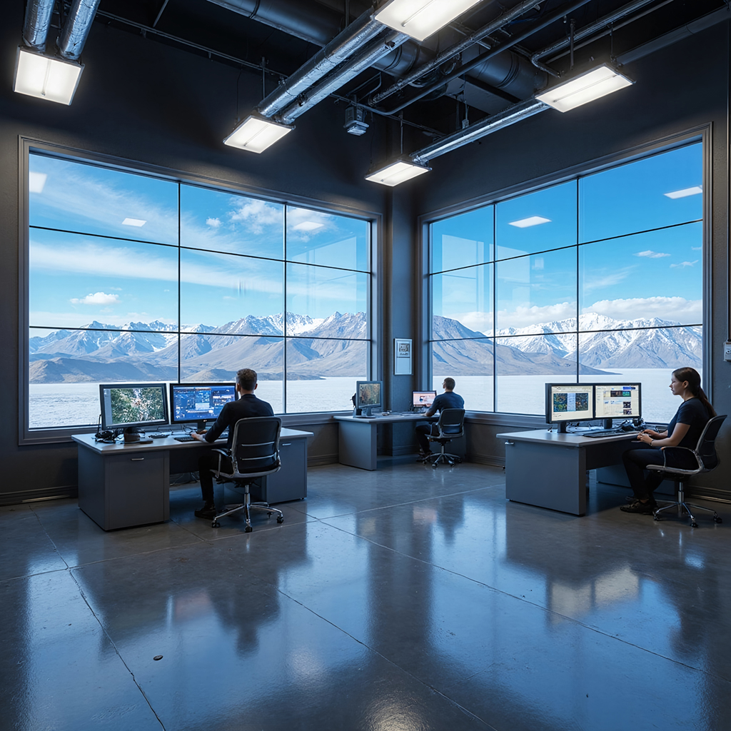
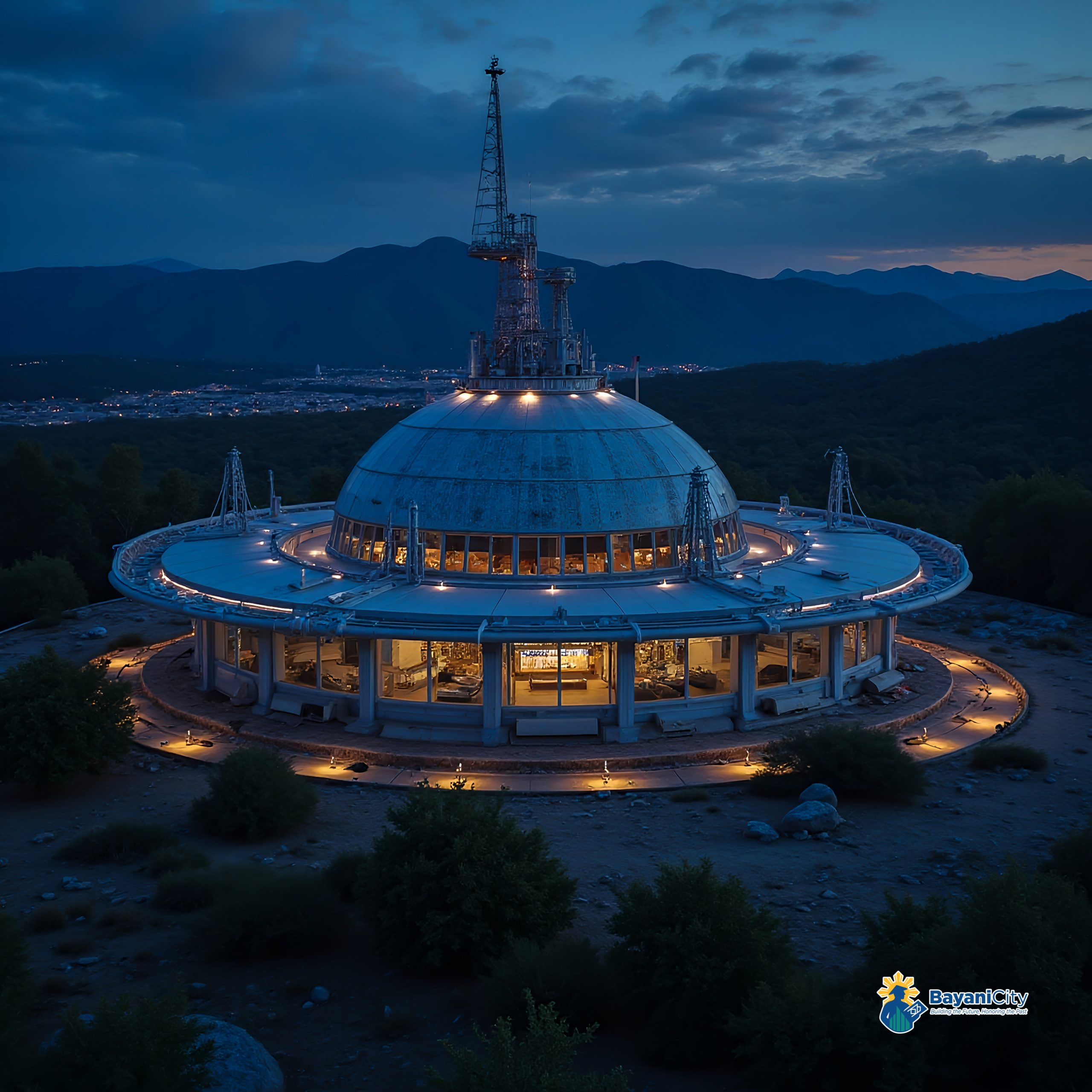
SatLinks parabolic antennas and command domes form a geometric array optimized for global signal reception. The interior control center houses AI-powered monitoring dashboards and real-time data analytics systems. Reinforced communication towers and fiber networks link to orbital satellites. Its minimalist concrete-and-glass form reflects precision and strength in aerospace engineering.
Lifestyle and Experience
Antennas turn toward the heavens, receiving whispers from orbit. Data streams in like light, painting Earths pulse across massive displays. Scientists trace storms, crops, and continents with awe and precision. The cosmos feels closer herescience made visible, connection made real.
Sustainability and Innovation
SatLink runs satellite data operations with renewable microgrids and smart cooling systems. AI compression reduces data transmission energy costs, while open-access Earth observation programs guide sustainable agriculture and disaster response. Its technology serving both global connectivity and environmental stewardship.
Investment and Value
Ground-station services generate revenue from agricultural analytics, defense, and climate-monitoring contracts. Strengthens national security and space-data capability. Creates long-term institutional partnerships and technology-transfer value.
A high-tech ground facility for satellite communications and Earth observation. It supports agriculture, disaster management, climate research, and defense through real-time remote sensing. Integrated with AI analytics, the center enhances decision-making, strengthens resilience, and advances space-based applications for sustainable development.
A state-of-the-art hub for satellite communications and Earth observation, providing critical data for agriculture, climate monitoring, and disaster response. Equipped with large parabolic antennas, control rooms, and secure data centers, it will support the space data economy and global connectivity initiatives.
Key Features:
| Investment Highlights: | Earth-observation services supporting agriculture and disaster response. |
| Value Proposition: | The Provinces First Satellite Ground Station |
| Benefits: | Enhances national space capabilities, supports climate resilience, boosts research and security |
| Why it Matters: | Strengthens disaster resilience and agri-tech monitoring |
| Role: | Enhances satellite communications and disaster response |
| Core Objectives: | Sustainability, innovation, resilience |
| Mission Statement: | Watching the Earth, protecting the future. |
| Key Features: | Earth observation, remote sensing, satellite comms |
| Land Area: | 9,400 sqm |
| Projected Gross Income per Year: | PHP 296,100,000.00 |
| Valuation: | PHP 29,980,125,000.00 |
| Initial Business Model: | Unit Lease |
| Main Business Model: | Satellite Station |
| 2nd Business Model: | Data Analytics |
| Other Income Streams: | Research Services |
| Estimated ROI Timeline: | 6 years |
Specifications:
| Building Size: | 49m(w) x 63.5m(l) x 27.2m(h) |
| Building Features: | 5-storey Satellite control/analysis labs; vibration/EMI treatments; ~2 m roof. |
| Unit Features: | 120 sqm / unit |
| Number of Buildings: | 3 |
| Units per Building: | 130 Satellite control & analysis labs |
| Total Number of Units: | 390 total units |
| Selling Price per Unit: | PHP 7,591,500.00 / unit |
| Lease Rate per Unit per Month: | PHP 63,262.50 / mo |
Related products


Future Arenas Innovation Park
FIP-2300 (Buildix) Modular Construction Manufacturing Plant with 3D Printing
Prefab and 3D printing enabling rapid urban deployment.
| Land Area: | 1.31 hectares |


Future Arenas Innovation Park
FIP-0300 (Cyphra) Cybersecurity Operations Hub with Quantum-Safe Encryption
Quantum-safe security services for regulated industries.
| Land Area: | 0.56 hectares |


Future Arenas Innovation Park
FIP-2000 (MetaPix) Digital Advertising & Media Production Studios using XR/Metaverse
End-to-end immersive content production for brands and media.
| Land Area: | 0.7 hectares |


Future Arenas Innovation Park
Cross-industry automation R&D with commercialization pathways.
| Land Area: | 0.56 hectares |


Future Arenas Innovation Park
FIP-1900 (Shiply) E-Commerce Logistics & Fulfillment Center with Robotics
Robotics-led fulfillment optimizing last-mile performance.
| Land Area: | 0.7 hectares |


Future Arenas Innovation Park
FIP-1600 (AutoWay) Shared Autonomous Vehicle Test Track & Depot
Safety-compliant AV proving ground for mobility partners.
| Land Area: | 1.31 hectares |


Future Arenas Innovation Park
Downlink-to-insight pipeline for agriculture, climate, and defense.
| Land Area: | 0.56 hectares |


Future Arenas Innovation Park
FIP-1100 (Electra) Electric Vehicle Assembly & Conversion Plant with Solid-State Batteries
EV manufacturing and retrofits aligned with fleet electrification.
| Land Area: | 0.94 hectares |


Future Arenas Innovation Park
FIP-1300 (Batrium) Battery Storage & Assembly Plant with Grid-Scale Solutions
Grid-scale storage assembly supporting renewable penetration.
| Land Area: | 1.31 hectares |


Future Arenas Innovation Park
Applied AI lab generating IP and enterprise solutions.
| Land Area: | 0.56 hectares |


Future Arenas Innovation Park
Ultra-secure comms proving ground for government and finance.
| Land Area: | 0.56 hectares |


Future Arenas Innovation Park
FIP-0200 (Cloudix) Cloud Services Data Center with Edge Computing
Edge-enabled infrastructure attracting hyperscalers and SaaS tenants.
| Land Area: | 0.94 hectares |